ŠUMAVA NATIONAL PARK AND PROTECTED LANDSCAPE AREA
Železná Ruda is located right next to Šumava National Park, with hiking options around Polom and Hůrka hills and Laka lake. Or start at Gerlova Huť or Brunst and go to Zhůří hill. A short car or bus trip takes you to Prášily, with its archaeological park, from where you can continue to Prášily lake and Polednik hill. Alternatively, you can go to Freuenthal valley towards Křemelná or to Rovina and Březník hills, where you will find the chapel of St Vintir and to Dobrá Voda, with a church and a Jewish museum, or to Hartmanice with a Jewish synagogue, and an eco-area called Hamižná. Further trips include destinations such as Srní hill, Hauswald chapel near the canal or Antýgl, with a walk around the Vydra river to Turner Chalet, or to Čeňkova Pila sawmill or to the Šumava plains. Take the local eco-bus – which operates during the summer – to visit the highest point in Šumava, the viewing tower on the peak of Boubín hill.
Polom (1,291 and 1,295 m)
You can walk up to the summit, taking a detour from Laka lake and following an unmarked trail from the Pod Polomem valley. Walk through the debris of a forest that fell during Hurricane Kyrill in January 2007. This area was amongst the most heavily affected. The name of the peak (Polom – ’windbreak’) is appropriate, as the area has witnessed many high winds. This natural catastrophe had one positive effect though; today we can enjoy a marvelous view from the bare peaks of the Polom ridge. This is the best view in the entire Železná Ruda area, allowing you to see the Velký Javor and Jezerní mountains, Pancířský ridge, Vysoký ridge and Hůrecký hill, Poledník, Ždánidla, Plesnou, Zhůří and Hadí and Březník hills.
Laka Lake (1096 m)
This is the smallest of the eight Šumava's glacial lakes, with a surface area of 2.78 acres (the perimeter of the lake is 870 m), and also the shallowest (it is slowly overgrowing, max. depth is 3.9 m, average depth is 1.45 m, with floating islets in the middle); however it has the largest water collecting area, 1,346 km2. The lake dam is artificial. Flora in the surrounding area includes deer fern, eared willow, round-leaved sundew, whorled Solomon’s-seal, soldanella montana and menyanthes, while swamp cinquefoils, bulbous rushes and tussock-sedge grow in the floating islets. The lake has a slowly-descending banks.
The water of the lake was once used to drive machinery (grinders) in the glass-works in Hůrka and Stará Hůrka.
Hůrka
This famous glass-making village once boasted 38 buildings and 596 inhabitants. The local glass-works were world-famous due to the production of Venetian mirrors with negative figural background. The Church of St. Vincent was built between 1788 and 1789 by Ignác Hafenbradel and his sons. The next owner of the glass-works, Jiří Kryštof Abele, a great promoter of Laka lake, added a long narrow slate-covered spire, topped by an onion-shaped cupola, to the church. Pilgrims and students hiking around Laka lake stayed in the parish building. The eternal light in the church, that had burnt since 1798, was extinguished in 1946, with the last mass being given by the dean, Kubín, at Christmas 1950. The church was then emptied and used as a barn, subsequently being demolished following the establishment of a military base in Dobrá Voda.
Abele had a family crypt, with a chapel of the Holy Rood, built next to the church in 1820. The church included a choir and organ. Wooden stairs in the back part of the chapel led down to the crypt. The coffins were arranged in two rows, one above the other, providing a final resting place for members of the glass-making families of the Hafenbradels and Abels (the bodies were mummified in glass coffins on marble desks decorated with inscriptions), amongst whom was also the father of popular writer, Karel Klostermann.
Following the expulsion of ethnic Germans from the area, the coffins were broken and the chapel was left derelict until 1998, when the decision was taken to reconstruct it. It was re-consecrated on 14th September 2003. The ruins of the church were uncovered and the tombs discovered in the area were repaired.
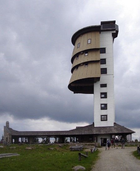
Poledník, 1,315 m
The 37 metre-high viewing tower, offering a splendid panoramic view, is all that is left from a large former radar station. It boasts an exhibition on the history of Polednik hill and on the Iron Curtain. A short educational trail leads through the dry forest, resulting from the double calamities of bark beetles and hurricane Kyrill, at the top of the hill.
Access to Poledník: follow the marked trails from: Prášily (10 km), Srní (11 km), Modrava (12 km) and Rokyty (13 km). Tel.: +420 376 599 009.
Opening hours: V., VI., IX.: daily 10 a.m. – 4 p.m., VII., VIII.: daily 10 a.m. – 6 p.m., X.: weekends only weather allowing 10 a.m. – 4 p.m..
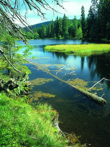
Zhůří
This is one of the most beautiful places in the entire Šumava, and was once a typical Šumava village (with 600 citizens) located on Hadí hill and boasting several glass-works and mills in the surrounding area. The village vanished after 1952. All that remains now is a bare but wonderful plane with meanders of the Křemelná river. A chapel on the site of the former church (now demolished) was restored, as well as biers and a monument to American soldiers killed on the 5th May 1945. You may observe the natural development of associations in the area of peat-bog, spring and wetland areas in the nearby Zhůrská pláň nature reserve. The view from Hadí hill to the massif of Javor hill and the main ridge of Šumava is an unforgettable experience.