TOURISM AND SPORT
Bikes, Scooters
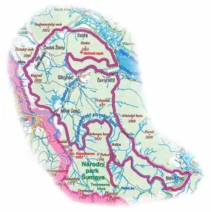
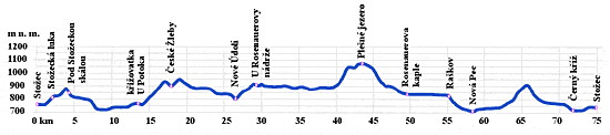
Cycling path from Stožec Chapel to Plešné Lake
From the village of Stožec ride to the crossroads Pod Stožcem and here turn to the right along the cycling path No. 1030. In a distance of 1,5 km from the crossroads there is a detour to Stožec Chapel and the rock. The slope is nevertheless steep and it is therefore necessary to park the bikes. Then get back to the marked path, circle round Stožec mountain and behind Dobrá continue along the blue-marked cycling path No. 1025. This will take you by the road to České Žleby and from there ride by so-called Zlatá path in direction to Stožec to the crossroads Mlaka. From here take to the left to Nové Údolí and continue along the red-marked cycling route No. 1023 towards the frontier crossing, which can be taken advantage of by those who wont the reach the peak of Třístoličník mountain. Our path mounts from Nové Údolí to the place of former Rosenauer reservoir and the beginning of the Schwarzenberg Floating Canal at the same time. Follow its artificially built bed for 9,4 km along the same cycling route up to the crossroads of Hučina. From here take the cycling route No. 1029 to Plešné Lake. From there you have to return along the same route. 900 m ahead of Hučina turn sharply to the right and continue along the cycling path No. 1023 to Nová Pec. From there you will have to mount towards the tunnel of the Schwarzenberg Floating Canal by the green-marked cycling path No. 1027. From its upper portal descent quickly but carefully along so-called Hučická road to Černý Kříž, from where only 3,5 last km remain to get to Stožec.
Hiking
First trip
Stožec – Nové Údolí – Krásná Hora – Mlaka – České Žleby – Stožec meadows – Stožec
From the railway station in Stožec (785 m) with the tourist information point (hereinafter only TIP) set out on the yellow-marked tourist path (hereinafter only TP) alongside the railway tracks to the crossroads ahead of the grade crossing with the TIP Bonarova Road (780 m; 0,7). Our trip continues on the yellow-marked TP across the grade crossing to the crossroads with the TIP Oslí Road (crossroads) (787 m; 0,3 or 1 km), beyond the railway track to another crossroads in front of the bridge across the Světlá stream. There is a TIP U stříšky (By the Shield) /bridge/ (797 m; 3,5 km) in here. Ahead of the bridge, the road turns slightly uphill along the Světlá stream to the Schwarzenberg Floating Canal. On the left side of the Světlá river, after approximately 1,5 km, there is an interesting natural formation, so-called Giant Pot - a boulder eroded by long lasting activity of water. From the crossroads ahead of the bridge continue by the yellow-marked TP to the TP crossing and the TIP Nové Údolí (830 m; 4,5 km) and continue by the road towards the frontier crossing to the TIP Nové Údolí /railway station/ (800 m; 5 km). From here you can return to Stožec by train, if the weather is not good. Our trip goes on along the red-marked TP, crosses the railway track and crosses the Studená Vltava by the bridge. Mount by the forest path to the TIP V Podkově (887 m; 8 km), from where the right path called Dolnokrásnohorská Road leads back to Stožec. You will nevertheless continue along the red-marked TP that will take you to the former settlement of Krásná Hora (914 m; 10 km), distant about 0,5 km from the border of Bavaria. Our trip continues to the TP crossing Mlaka (906 m; 13 km), from where a frontier crossing to Bavarian Bischofsreut is accessible by the yellow-marked TP in the left direction. You will continue to the right along the yellow-marked TP copying the Golden Path past the Stone Head (973 m; 14,5 km) - a point offering beautiful view of the surrounding landscape. You will come to the historical village of České Žleby (920 m; 16,5 km) with several possibilities of refreshment. There also is an important crossing of the blue-marked and yellow-marked TP. Our trip continues along the blue-marked TP down the road past the TIP Pod Spáleništěm /game-keeper's lodge/ (856 m; 17,5 km) to the TP crossing Stožecká luka (805 m; 18,5 km). Go on along the yellow-marked TP passing through the meadows to the TIP Stožec /railway station/ (785 m; 20,5 km) where our round tour gets to its end.
Second trip
Stožec – Nové Údolí – Rosenauer reservoir – Jelení Vrchy – Černý Kříž – Stožec
The first part of the trip is the same as in case of the first trip. From the crossroads ahead of the bridge continue by the yellow-marked TP to its crossing with the red-marked TP to the TIP Nové Údolí (830 m; 4,5 km) and from here continue to the left along the red-marked TP to the crossing By Rosenauer reservoir (925 m; 8 km). From here go on by the blue-marked TP alongside the Schwarzenberg Canal past the crossing U Oslince (916 m; 13,5 km), Ministerka and Oslí road (914 m; 14,5 km), Hučina (902 m; 18,5 km) to the TIP Tunnel /upper portal/ (900 m; 20,5 km). Here turn down to the left from the blue-marked TP and from the Schwarzengerg Canal and continue along the green-marked TP past the crossing Hučina (785 m; 23 km), Lesní potok /estuary/ (740 m; 25,3 km), Hučicská road /crossing/ (739 m; 26 km) to the TIP Černý Kříž (745 m; 27 km), and from there continue along the blue-marked TP on the right bank of the Studená Vltava to the TIP Studená Vltava /foot-bridge/ (765 m; 29 km). Go on down the road (no tourist marking) alongside the railway track to the village down to the TIP Stožec /railway station/ (785 m; 30,5 km) where our round tour gets to its end.
Third trip
Stožec – Stožec meadows– Stožec rock – Stožec Chapel – foot-bridge across the Studená Vltava – Stožec
Start from the railway station with the TIP Stožec /railway station/ (785 m) along the yellow-marked TP to the TIP Stožec meadows (805 m; 2,5 km). Then continue to the right along the blue-marked TP to the TIP Pod Stožeckou skálou /bellow the Stožec rock/ (852 m; 4,5 km) with the detour to Stožec Chapel (950 m) and Stožec rock (974 m; 6 km). Return to the TIP Pod Stožeckou skálou /bellow the Stožec rock/ (852 m; 7,5 km) and go on along the blue-marked TP on the forest road to the TIP Studená Vltava /foot-bridge/ (765 m; 10 km). Turn right down the road (no tourist marking) alongside the railway track to the village down to the TIP Stožec /railway station/ (785 m; 11,5 km) where our round tour gets to its end.
(TIP = tourist information point, TP = tourist path)
Cross-Country Skiing Hints
Easy track – Small Stožec round trip
Stožec (by the Municipal Office) – across the meadows to the Tovární road – on the crossroads „U jelena“ to the right against the hill – along Ministerka to the crossroads with Bonarova road – by Bonarova road across the meadows back to Stožec
Track of medium difficulty – Stožec past České Žleby and back
Stožec (by the Municipal Office) – across the meadows in direction of Nové Údolí – along the border across the Studená Vltava and along the Mechový stream – Krásná Hora, Mlaka (frontier crossing to German Bischofreut) – Kamenná Hlava (Stone Head) in direction of České Žleby – past the ski slope in České Žleby – by Lenorská road through the forest to the crossing Below the Stožec rock – Stožec meadows and back to Sožec
Difficult track – Stožec, Schwanzenberg Canal, lake, Seebach, Jelení Vrchy, Stožec
Stožec (by the Municipal Office) – Bonarova road – Ministerka to the left in direction of Schwarzenberg Canal, to the crossroads Hučina Jezerní road – from the lake back to the crossing „U stříšky“ (By the Shield), turn right to the road Seebach towards the Canal – to the right along the Canal in direction of Jelení Vrchy (possibility of refreshment) – along the tunnel to the right on Medvědí read – to the left on Rudolfova road up to the road to Hučice – then to the left on the ploughed road some 200 metres and then to the right along Krejčová road – from the crossing „U jelena“ to the right along Tovární road back to Stožec
Downhill Skiing
Other Activities
Stožec is sought by tourists mainly thanks to its position amidst forests, offering endless walks or rides on bikes on the perfectly maintained tourist paths. Besides that, it is possible to take advantage of so called Vltava Path, first copying the stream of the Studená Vltava and from the village of Smolná Pec the stream of the Vltava, till its confluence with the Teplá Vltava in Nová Pec, which is situated at the beginning of the "Czech Sea" - the Lipno water reservoir. With its 16 km it is the longest in-line skating path in Bohemia.
The fans of romantic bathing in the nature and of water games may do so at the weir in the Studená Vltava right in the village. The weir was built here to retain and conduct waters to the local water power plant.