TOURISM AND SPORT
Bikes, Scooters
Scooters

All scooter trips lead on non-public or scarcely used roads and paths. Each trip has a guide giving information on interesting places. Helmets are provided and so is transport (minibus) to the starting point and destination of the trips.
A. Through thevalley of the Račí (crayfish) stream to the Vltava
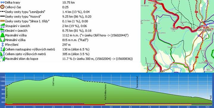
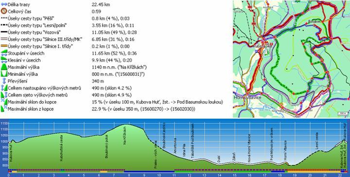
Following the climb to Obří mountain with a 'wedding cross' atop, there is a gentle downhill ride with views of Luzný, Velká Mokrůvka and Malá Mokrůvka hills. The trail turns towards the Račí (Crayfish) stream at the crossroads at the foot of Světlá mountain, passing the ruins of the former Šeravská smelting-works; you can still find pieces of glass documenting the history of the glass-production in this area. The trail continues along the Račí stream and ends with a downhill ride to Anenský farmstead.
B. Along Pravětínský stream to Vimperk
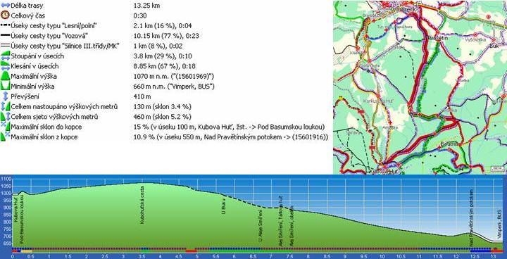
Beautiful views of many peaks of the Šumava west of Boubín make the uphill ride through the valley more pleasant experience. After leaving the Kubohuťská path the trail descends in the direction of the Alley of Reconciliation and continues through the valley of the Pravětínský stream along various rock formations to Vimperk.
C. To Boubín forest
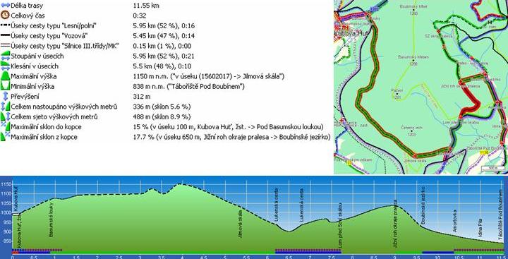
A beautiful trail for those who appreciate more than mere downhill rides. The trail crosses Bázumské meadows along Horní Bázumská path, passing the Elm Tree Rock and continuing along Lukenská path to Boubín forest, to the area with a small pond. From the pond it continues past the Idina sawmill Information Centre and ends at a car park where you can find refreshment stalls.
D. Through Cikánské (Gypsy) valley to Husova lime tree
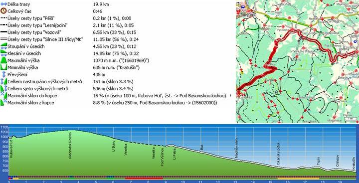
The longest scooter trip will take you back to the 15th century. At the beginning the trail is the same as the one through the valley of Pravětínský stream, but then turns north-east through the village of Buk. It continuous through a lovely alley followed with a long descent through Cikánské valley to the well-known Husova lime tree in Chlístov. It is the second biggest tree in South Bohemia where Jan Hus used to preach sermons in his times already.
E. Time-measured slalom track on the ski slope Pod Obrovcem
This 350-metre long slalom down the ski slope below Obrovec mountain with time-measuring provides as much adrenaline as you like. There is a restaurant below the slalom.
Bikmes
A. From Boubín to Schwarzenberg canal
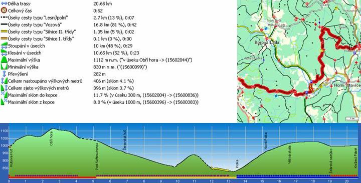
A pleasant cycling trip through Lenora and České Žleby along the Bavarian border into Nové valley. There is an option to cross over to the Bavarian town of Haidmuhle, or you may continue uphill to the first section of the Schwarzenberg canal. The trail continues along a comfortable path following the route of the canal over Jelení hills into the town of Nová Pec, or you may return to Nové valley and reach Stožec along a paved road. You can then take the train from Nová Pec and Stožec back to Kubova Huť.

B. Through the valley of Cikánský (Gypsy) stream and the Blanice to Volary
This trail will take you to the less visited parts east of Boubín, past Husova lime tree through Kratusín and Záblatí and up to the highest pond in Bohemia – the Křišťanovický pond. The journey ends in the picturesque town of Volary, where you can also take the train back.
C. Around Boubín
A popular and comfortable trail around Boubín, including a visit to Zámeček area, Boubín forest and the Idina saw-mill Information Centre.
D. Over the Liščí Ridge to Knížecí Pláně
This trail goes westward of Kubova Huť, crossing the Vltava at the locality Polka and continues through huge boulders to the popular cycling destination of Knížecí Pláně. You can return via the village of Borová Lada or continue through Časté valley to Strážné.
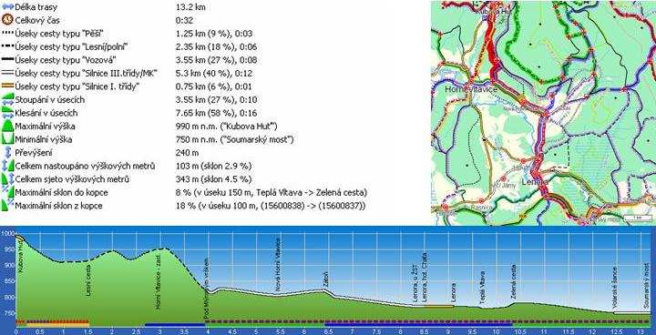
E. Let’s go swimming near Soumarský bridge
This is only a downhill ride, ending at Soumarský bridge, where you can cool down in the Teplá Vltava river. The trail goes through Zátoň and Lenora to Volarské šance (ruined fortifications from the Thirty Years’ War) at Soumarský bridge.
Hiking

All trails described start at the tourist signpost next to the railway station. It is possible to return to Kubova Huť by train from all routes.
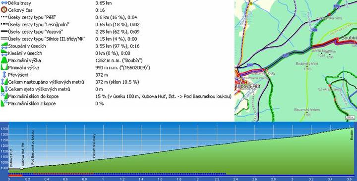
A. Climb to Boubín
A typical hike for visitors to the Šumava area. The shortest route to the peak of Boubín hill leads from Kubova Huť. Starting at the signpost at Kubova Huť train station, the trail passes by some old army bunkers and leads up to Bázumské meadows, with a sheltered resting place. From Bázumské meadows, which boast of the ‘bank of the best genes’, the best spruce to be found in the Boubín area, the trail follows Severní (Northern) path, offering some magnificent views of the western part of the Šumava; there is a wooden walkway for the last 1.5 km, which will take you to the very peak of Boubín hill. A lookout tower was erected at the peak of Boubín in 2004. Its observation platform is the highest place in the Czech side of the Šumava and offers splendid panoramic views from the lookout tower. You can return to Kubova Huť from the peak of Boubín or continue towards Boubín forest, taking the train back from Zátoň.
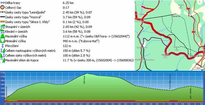
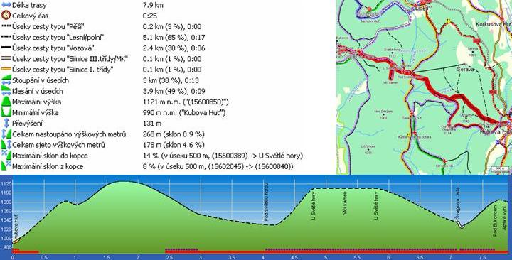
B. From the springs of the Volyňka to Světlohorská reservoir
The red-marked trail from Kubova Huť copies Hraniční path and passes by a ski school resort. You will see the ‘Wedding Cross’, which was erected to commemorate the 25th wedding anniversary of John of Schwarzenberg and Terezie of Trautmansdorf. It stands near the path on the peak of Obří mountain. Next, you will reach the crossroads below Světlá mountain, after a descent with open views of Luzný hill. This is the starting point of the marked trail to the springs of the Volyňka stream. After returning to the crossroads at the foot of Světlá mountain, follow the yellow-marked tourist trail in the direction of Lipka. Take a sharp left turn after 1 km onto a forest gravel path and you will reach Světlohorská reservoir after one more kilometre. It spreads out about 50 m left of the path. From there you can continue to Lipka and take the train back or follow the marked cycling trail Lipka – Kubova Huť (No. 1032)
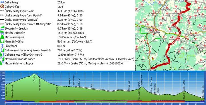
C. Along the Celtic trail to Věnec refugium
After climbing to the peak of Boubín hill and returning to Severní Boubínská path, follow the red-marked tourist trail, passing by the gamekeepers’ lodge called U Bendů to the village of Veselka, where the Celtic trail turns right off the red-marked trail and continues to the village of Buk. Walk along the road from Buk to Svatá Máří, continuing along the red-marked tourist path up to Mářský hill with a lookout tower and a stone sea. The descent to Budilov zigzags amid huge boulders and, following the red trail, you will reach the Královacký boundary stone, situated on the left side of the path.
The Celtic trail continues left through a forest and ascends to the old Celtic fortress (refugium) known as Věnec, nestled at the top of the hill. The last part of the trail descends along the blue-marked trail to the train station in Lčovice. There is a friendly refreshment stall a bit further up, near the Volyňka river.
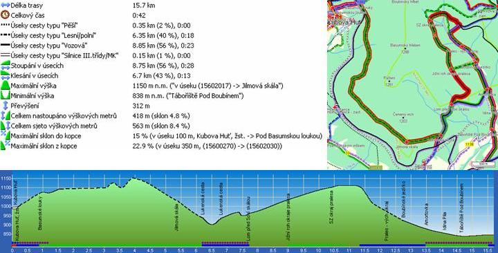
D. Along the nature instructional path to Boubín forest and Boubín Pond
The beginning of this trip is identical with the climb to Boubín hill; however it turns off to the right after 1 km at Bázumské meadows and continues along the green-marked nature instructional path copying Horní Bázumská trail. There are some magnificent views of the western peaks of the Šumava, mainly of the huge Roklan and stony Luzný hills. The trail continues along the hillside of Bázum to the Elm Tree Rock monument and, after a short descent, turns leftwards on the Lukenská trail and goes on for approximately 1300 metres to the fence of the Boubín Reserve (this section of the trail is not marked).
Follow the nature trail around the forest to the pond and further on to Idina sawmill Information Centre and the railway station in Zátoň.
E. Hike to the Alps viewpoint past Vlčí (Wolf) stone
Starting at Kubova Huť, hike along the red-marked tourist path over Obří mountain (1114m), passing by the ‘Wedding Cross’ near the path.
Continue along Hraniční path, still following red tourist marks through the crossroads at the foot of Světlá mountain. Following a short ascent across the hillside of Světlá mountain, there is a short and also red-marked trail leading to the spot at which the last surviving wolf in Šumava was hunted down (2. 12. 1874). From there the path continues downhill onto the road where the village of Švajglova Lada once stood and continues in the north-west direction to the Alps Vista at the foothills of Bukovec hill. On a clear day you can see as far as the Totes Gebirge peaks and the limestone foothills of the Austrian Alps. You can return along the same route or take the red-marked tourist path to the huge fir tree below Kamenná hill. There you will find a crossroads with a yellow-marked tourist trail, which will take you to Michlův house and the train station in Lipka.
Cross-Country Skiing Hints
See the map for the marked cross-country skiing tracks of the Kubova Huť ski resort.
Yellow 1 km
Blue 2 km
Green 3 km
Orange 5 km
Red 25 km
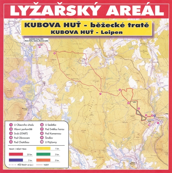
White Golden Trail Kubova Huť – Miterfirmiansreut 50 km (back by Skitaxi 721 267 867)
Connection to the Šumava arterial trail at Šindlov (12 km) – the red-marked trail
Up-to-date information about condition of cross-country skiing tracks
Downhill Skiing


Mitterdorf Ski ResortHochficht Ski Resort
Other Activities
Nordic Walking / 777 327 490
Horse riding / 721 368 554
Tennis
Massage
Infrasauna
Climbing wall
Bouldering
Nature trail of Hornovltavické Pastviny Reserve
Interactive children trail
Igloo